

In the early 1960s, an Irish surgeon working for the British colonial service in Uganda stitched together a set of striking maps that changed cancer research.
Denis Burkitt’s cartographies of a pediatric jaw tumor - what would become known as Burkitt’s lymphoma - showed a dramatic “belt” across tropical Africa that appeared to vary with altitude and rainfall. Those images nudged the world toward the idea that some cancers are caused by viruses, helping to catalyze the rise of viral oncology.
But as David Reubi and Thandeka Cochrane argue in a new article, the truly consequential story sits behind the maps: the human, material and epistemic infrastructures that made those maps possible in the first place.
What is a “cartographic infrastructure”?
Reubi and Cochrane coin the term to capture the layered assemblages that allow maps to come into being and to carry authority. They distinguish three intertwined components: epistemic infrastructures (theories, funding flows, forums, labs), surveillance infrastructures (the practices and tools that produce and interpret data), and human infrastructures (communities, norms and social relations).
Seen this way, a map is not a neutral picture of the world; it is a surface that conceals a world of work. And because those worlds are historically contingent and politically charged, the truths maps appear to stabilize are also fragile.
“Maps tend to obscure the infrastructures that undergird their formulation and existence.” —Reubi & Cochrane
A belt on the continent, a revolution in the lab
Burkitt’s maps - published across Nature, BMJ, Cancer and the East African Medical Journal - plotted cases of the tumor and suggested a climatic logic: the disease seemed to depend on humidity and altitude, hinting at a mosquito-borne, viral cause.
The chain reaction was rapid. In 1964, working directly with Burkitt’s Ugandan samples, Anthony Epstein and colleagues identified viral particles in lymphoma cells, cementing a new frontier for cancer research and helping to institutionalize viral oncology through the resources of the U.S. National Cancer Institute and other funders.
The maps did not “prove” anything on their own; they rendered a hypothesis legible and fundable.
The epistemic backstory: Geographical pathology’s Africa problem
Burkitt did not invent this approach; he walked into an existing research tradition called geographical pathology that compared cancer patterns across places to infer environmental causes.
After World War II, geographic comparisons - tied to committees at the International Union against Cancer and backed by British and American funds - made Africa seem like a uniquely revealing “laboratory.” This orientation married Enlightenment curiosity to imperial imaginaries of African difference: the belief that African bodies and environments, because they were “less sophisticated,” could expose causal mechanisms obscured in Euro‑America.
In Kampala, where Burkitt worked, this tradition had already been built into institutions, registries, and seminar cultures by figures like the pathologist Jack Davies at Makerere and Mulago. It furnished Burkitt with theories, contacts and money.
Why this matters: The paper insists that ideas travel on infrastructure. What looks like experimental inspiration often depends on committees, symposia, registries, and colonial budgets that enabled certain kinds of questions to be asked - and others to be ignored.
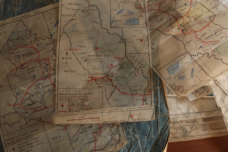
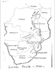
Surveillance, colonial‑style: From postal surveys to “tumour safaris”
Burkitt’s surveillance method was part epidemiology, part expedition. He first mailed illustrated questionnaires to medical units across British and non‑British Africa, asking doctors whether they had seen the distinctive jaw tumors in children. Then came the now‑legendary “tumour safaris”: in 1961, he and two colleagues drove 16,000 kilometres over ten weeks across eight countries in a battered Ford station wagon, visiting more than fifty hospitals; he followed up with two shorter trips by plane.
The logistics rested on colonial postal routes and road networks, the very arteries that had been laid down to consolidate rule. The data rested on testimony from mostly white clinicians - “authoritative statements of competent observers” - because biopsies and records were sparse. Burkitt fully admitted that his method was impressionistic, designed to yield “misty images” that warranted later, more rigorous study.
Read that again: the “map” began as a conversation across a continental doctor‑to‑doctor network, ferried by gravel roads, airstrips, letters and rest houses. The picture we remember is inseparable from the infrastructures of empire.
Map consciousness: Turning pins into hypotheses
Back in Kampala, Burkitt spent hours with wall maps and pushpins, marking every reported case and performing comparative map analysis - stacking his disease map against maps of rainfall, elevation and vegetation, a set of practices common in colonial tropical medicine.
Crucial, too, was the interpretive community around him. The entomologist Alexander Haddow recognized that Burkitt’s “lymphoma belt” resembled older zoogeographical maps of African bird habitats (and thus insect ecologies), reinforcing the idea of a vector‑borne virus. What we see here is the recursivity of cartographic knowledge: old maps do not just fade; they seed the next map’s hypotheses.
People as infrastructure: The colonial medical community
The article’s most unsettling contribution is to show how the human network that sustained Burkitt’s project was a racially stratified colonial community. Postwar British Africa’s medical world was a small society of white doctors and their families, bound by shared professional routines, missionary ties, religious practice, and an imperial ethos of adventure.
Those bonds opened doors, filled guest rooms, and smoothed access to files and operating theaters across borders. They also narrowed the field of recognition: African doctors and nurses appear at best as assistants, at worst as afterthoughts or subjects of condescension in Burkitt’s diaries and correspondence. A scientific map, in other words, was scaffolded by a social map of race and power.
When infrastructures decay
Infrastructures age. After 1960, as independence movements swept the continent, the colonial medical communities disbanded; administrative access, travel permits, and on‑the‑ground networks frayed.
Simultaneously, cancer science shifted: viral oncology turned toward molecular biology, and descriptive epidemiology sought statistical control rather than exploratory comparison. Funding dried up; committees dissolved.
By the mid‑1970s, Burkitt - the man whose maps helped make viruses thinkable in oncology - was pushed to the margins of a field that no longer valorized safaris‑as‑survey. The paper’s point is not tragic irony; it is a structural observation: maps are fragile because their infrastructures are fragile.
The moral ambiguity of map‑making
Reubi and Cochrane do not dismiss Burkitt’s achievement. Rather, they make the ethics legible.
The same infrastructures that enabled discovery also reproduced extraction and inequality - Africa as research reservoir; white testimony as gold standard; imperial roads as research assets.
To study maps as infrastructures is to hold two truths at once: maps make worlds (they change research agendas, open laboratories, and reorient funding), and maps are made by worlds (they depend on histories of empire, segregation and development logics).
Why this history matters now
If you work in global health, climate risk, or urban governance, your day likely begins with a dashboard - points on a map that claim to show where need is greatest or risk is rising.
Reubi and Cochrane offer a method for auditing those images. Ask: What epistemic infrastructures are privileging some variables and suppressing others? What surveillance practices - sampling frames, reporting protocols, travel budgets - generate these points? Which human communities - whose credibility, which languages, what kinds of labor - are underwriting the dataset? The answers will not invalidate the map; they will tell you what it can and cannot responsibly do.
Five takeaways
Every map is an archive of infrastructures. Read the legend, then read the funding acknowledgements, travel logs, and committee minutes that made it.
Exploration methods leave epistemic residues. “Tumour safaris” gave cancer science a viral turn; older ecological maps gave Burkitt a hypothesis to test. Today’s dashboards will seed tomorrow’s lab agendas.
Authority travels along social lines. Burkitt’s reliance on white clinicians’ testimony wasn’t incidental; it was constitutive. Ask who gets to say a case exists.
Infrastructure is fragile by design. Political transitions and paradigm shifts unmake map‑worlds. Build with redundancy and memory.
Interrogate the moral economies of mapping. When maps are born of unequal conditions, accountability requires naming the asymmetries—and redistributing the benefits of knowledge.
Read the research
Reubi, D., & Cochrane, T. (2025). Cartographic infrastructures: Geographical pathology, tumour safaris, and colonial networks in British East Africa. Social Studies of Science, 1–30. DOI: 10.1177/03063127251364513
David Reubi is Associate Professor (Reader) of Sociology and History of Global Health and Medicine at King’s College London. David's work explores the politics of knowledge in contemporary biomedicine and global health.
Dr Thandeka Cochrane is a Research Associate on the Cartographies of Cancer project at King's. Thandeka's current research focuses on cancer registries in Africa. For this project, she is conducting archival research in London on the colonial history of cancer registries in Africa and the British Empire Cancer Campaign.